Are you a commercial drone pilot looking to grow your business in 2022?
Have you found success in aerial photography, but you just need more? If you're looking for more market share as a drone service provider, you're not alone.
One of the best ways to grow your drone business is to offer more services. You can use drones across a wide range of industries, but some services are not as "high demand" as others. You must choose how to expand carefully.
One of the fastest-growing segments of the drone service industry is surveying and mapping.
Aerial surveying and mapping saves both time and money. Drones used for this purpose can also improve safety and streamline project management. In fact, more and more professionals continue to hire commercial drone pilots to perform these tasks each year.
Unfortunately, some UAS designed for mapping can cost close to, if not over, $100,000.
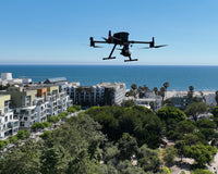
Whether you're already surveying with your drone fleet or you're looking to add the service to your operation, you need a capable platform. And, especially if you're just getting started, you need that at an affordable price.
Drone companies release something "bigger and better" each year, but you can't go wrong with a "tried and true." In the case of mapping and surveys, the durable, reliable DJI Phantom 4 RTK (which starts at $6,200) provides both quality and affordability.
Here, we'll break down why it's still a very capable drone in 2022.

First off, what's an RTK drone?
There's a destinct difference between standard drones and those that use real-time kinematic (RTK) or post-processed kinematic (PPK) positioning.
Sure, you can use entry-level commercial drones for mapping, such as the DJI Mavic 2 Pro. However, it doesn't provide a the level of accuracy precise enough for professional mapping and surveying missions.
When a drone includes RTK or PPK, it reaches centimeter-level positioning.
Here’s a high-level overview:
Just about every drone includes a Global Positioning System (GPS). That system essentially provides your drone camera with basic positioning accuracy.
However, GPS does not tie back to the ground. Therefore, its accuracy in the vertical axis is not very good, and it’s typically not centimeter-accurate in the horizontal axis.
RTK and PPK allow your image's metadata to be corrected for accurate GPS positioning. Essentially, it's the most precise way to gather the data you need form a mapping and/or surveying mission.
And, if you want to do that commercially, you need an RTK or PPK drone in your fleet.
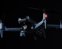
Breaking down the DJI Phantom 4 RTK
Alright, let's start off by addressing the elephant in the room: DJI released the Phantom 4 RTK back in October 2018.
In tech years, that seems like a really, really long time ago.

However, when your kit is built to last, time won't sink it as quickly as, say, your iPhone XS. The Phantom 4 RTK was, indeed, built to last.
In fact, our own solution specialist and drone training expert Doug Wiedman often opts to grab the Phantom 4 RTK for many of his own missions.
"The P4 RTK is a proven and reliable platform," Wiedman said.
"While it is nice having the latest and greatest, as ultimately we all know, we buy these crafts to go out and work to create a return on investment. Newer crafts need various firmware updates to fix bugs and improve functionality constantly.
"The Phantom 4 RTK is mature, thus it's been through all of that already. We need to be able to go into the field and count on the technology to work, and to rely a proven workflow process to yield consistent data. This drone provides a level of confidence you just can't get, yet, with newer platforms with similar technology."
RTK Feature
Let's start with the basics.
The Phantom 4 RTK comes with an RTK receiver and global navigation satellite system (GNSS) module. In fact, it's built right into the drone.
Because it uses DJI's TimeSync system, the UAS produces pinpoint-accurate metadata for image location. Additionally, the gimbal movements and the drone's position are calibrated in flight to ensure location accuracy.
In fact, the Phantom 4 RTK can achieve an impressive 1cm+1ppm RTK horizontal and 1.5cm+1ppm RTK vertical positioning accuracy.
And, if your missions take you away from strong wireless signals, you can pick up the D-RTK 2 GNSS Mobile Station, which provides real-time differential corrections that generate centimeter-level positioning data for improved relative accuracy while out in the field.
The station allows for accurate mapping, even in the most challenging off the grid environments.
Now, more often than not, a UAS with this level of capability coupled with a base station will set you back around $20,000. The Phantom 4 RTK complete package, however, comes in at just $8,419.
"P4RTK is still one of the only aircraft available for less than $8,500," Wiedman added.
"It's still unmatched in terms of cost-of-ownership versus return-on-investment (ROI). Even the replacement batteries are relatively inexpensive compared to the newest craft."

The Sensor
The drone also uses a 1-inch, 20-megapixel CMOS sensor, which remains one of the main reasons photographers continue to use the standard Phantom 4 Pro.
It also includes a mechanical global shutter, which eliminates the risk of rolling shutter blur in your photos, and it records in up to 4K at 60fps. Those features surpassed even the most popular drones to follow, including the Mavic 2 Pro.
"With a 1-inch global, mechanical shutter, the P4 RTK fundamentally removes the "rolling shutter" effect," Wiedman said.
"While photogrammetry software has developed numerous algorithms to help remove and "deal with rolling" shutter sensors, it is far superior to not have the rolling-shutter effect in images for software to remove."
Due to the high resolution, the Phantom 4 RTK can achieve a ground sample distance (GSD) of 2.74 cm at 100 meters flight altitude
Essentially, in 2022, Phantom 4 RTK still captures the kind of professional-quality detail your clients expect.
Other specs
With a maximum flight time of between 25-30 minutes per charge, the Phantom 4 RTK can stay airborne long enough to capture the specific area you need. And, a standard pack comes with two intelligent flight batteries, so you'll be set to swap out and quickly get back to the sky.
It's also lightweight (just under 3.1 pounds) and easy to transport. This is especially true if you also purchase the rugged rolling hard case produced by GPC.
Phantom 4 RTK uses the OcuSync transmission system, which provides stable, reliable HD image & video transmission for over four miles.
You're also able to use third-party flight planning apps -- DJI Mobile SDK-enabled -- such as DroneDeploy and DroneLink. And, its 4-sided obstacle-avoidance detection systems help to keep you from running into those pesky trees and infrastructure during extended mapping missions.
So, you can very easily automate waypoint flights, and know that your aircraft will complete the task safety and efficiently.
What's more? Most Phantom 4 RTK replacement parts cost a fraction of what it takes to replace equipment on new UAS.
So, you know the technical specs, but there's still one pressing question...

Why should you get a Phantom 4 RTK in 2022?
Many industries need aerial mapping and surveying services.
From construction and industrial inspections to mining and the energy sector, there's a lot of opportunity for you to expand your drone operation. If you're just starting to grow, it's crucial to find a drone that can perform all of your tasks without breaking the budget.
The Phantom 4 RTK is still, even in 2022, the best entry-level RTK drone on the market. And, at its price point, the competition has yet to produce a viable alternative.
With the ability to achieve 1cm+1ppm RTK horizontal and 1.5cm+1ppm RTK vertical positioning accuracy, its high-quality sensor, and its overall performance, the Phantom 4 RTK might just be the perfect mapping and surveying drone for you and your team.
Because its affordable, precise, and backed by DJI’s warranty and service support, you'll be able to confidently take flight each and every time you put your fingers on the sticks.
So, if you're in the market for a mapping and surveying drone, don't sleep on the Phantom 4 RTK. Sure, plenty of new drones enter the marketplace all of the time but, as we said before, shiny and new doesn't always beat tried and true!
Still not sure which way to go? We can help with that.
At Advexure, we don’t just sell drones; we provide solutions. We work with a variety of UAS operators across different industries, from police departments to powerline inspectors.
We understand that you don’t just need the drone, you need the result it provides.
Let’s find the right solution for you! To get started, just open the chat box, or contact us here.
We’re always here to help you with your UAS operation!