If mapping takes up a massive chunk of your organization's aerial operations, the WingtraOne GEN II might just be the perfect UAS to add to your fleet.
After a six-year wait, WingtraOne GEN II was released in early August 2021, and recently made its way back to the headlines after being added to Defense Innovation Unit's Cleared List of drones as part of Blue sUAS 2.0.
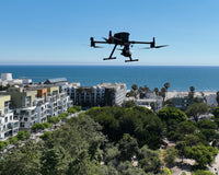
Aside from being an aesthetic standout as a bright orange VTOL, the UAV is a mapping powerhouse. And, with WingraOne's impressive specs and unparalleled technology, our partners at Wingtra had more than large-scale aerial surveying in mind.
In this article, we break down WingtraOne GEN II to help you decide if it's right for you and your drone program.

WingtraOne GEN II: The Features
With WingtraOne Gen II, mapping no longer has to take a considerable chunk of your energy, time, and money.
Okay, maybe that last part is a bit of a stretch, but investing in this UAS is well worth it.
Wingtra's VTOL drone is well-equipped to facilitate aerial mapping operations without compromising accuracy levels. It's also a heavy-duty UAS that boasts strong flight times.
Let's start with design.
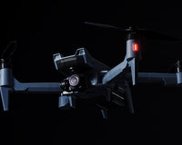
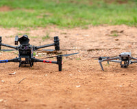
A unique design
As a VTOL UAV, its weight is 8.1 lbs (3.7kg), and it has a maximum payload weight of 1.8 lbs (800g). Therefore, it's not as compact as other mapping UAVs such as, say, the DJI Phantom 4 RTK.
Another point to note is that the drone is a fixed-wing multirotor. That means you'll get you get superior flight efficiency, as well as convenient vertical landing.
The drone, itself, is made up of only four (4) moving parts: two rotors for propulsion, and two flaps for steering. And, it is built to house some fairly heavy cameras (you'll read more about that below) which do not affect flight performance in the slightest.
WingtraOne does take off from what's called a "middle stand," which isn't symmetrical. Thus, it's important to note that you'll need to match the stand with the shape of the airframe because it can't be inserted properly in the wrong direction.
Now that you have a good sense of the design, let's talk about performance.
An ample flight time
With a WingtraOne Gen II, which requires two Wh batteries, you can fly for up to 59 minutes under ideal conditions.
Additionally, the battery system is swappable, which makes it ideal for reducing downtime. When you've got a large mission and your power is low, you can pause your flight, quickly swap your batteries out, and resume without losing information you've gathered.
That ample flight time also contributes to WingtraOne’s broad coverage, and a subsequent increase in data collection speeds, which will come in handy during your large-scale mapping operations.
And, as we mentioned, it's on the latest iteration of the Blue sUAS cleared list, so let's talk about security.
A cyber-secure system
WingtraOne Gen II might be the most suitable FAA and 848-FY20-NDAA-compliant drone mapping solution. In fact, it's the only VTOL mapping solution out of the 14 current Blue UAS drones.
Related Article: 5 Blue sUAS Drones to Watch for in 2022
The UAS has undergone an extensive cyber-security evaluation and NDAA-compliance check. It also includes ChaCha20 (256-bit security level) telemetry with air-gapped operations.
You won't find a more secure VTOL drone in the United States.
So, what about flight coverage?
An impressive maximum flight coverage
WingtraOne Gen II covers a lot of ground.
According to Hades Geodeesia CEO Vaiko Veeledi, it mapped about 7.8 times more area than his previous drone did two years prior in the same amount of time.
“Mapping the same road two years ago, we used a multicopter drone, covering 3 km (1.8 mi) of road per day. Right now, in that same time, we cover the whole road, 22 km (14 mil), with WingtraOne.”
Additionally, under equal ground sampling distance (GSD) parameters -- .5 in (1.2 cm)/px GSD -- WingtraOne covers approximately 14 times more area than the DJI Phantom 4 RTK. While most multicopter drones would cover 3,000 acres in about 10 days, WingtraOne does it in only three. Effectively, you'd be looking at about 1/3 the overall mission cost.
An extended flight coverage is another critical aspect you cannot afford to overlook if you're a surveyor or mapping professional. The WingtraOne GEN II gives you just that.
So, what about payloads ?
Payloads
If you like the idea of swappable payloads, WingtraOne Gen II has you covered.
Additional payloads, such as multispectral, RGB, and oblique cameras, will broaden your operational abilities.
Here's a breakdown of each that's offered:
RGB cameras - Sony RX1R II, Sony Alpha 6100, and Oblique Sony ɑ6100.
Multispectral cameras - MicaSense RedEdge-MX and MicaSense RedEdge-P.
These imaging payloads and the drone's vertical landing ability enhance its durability by protecting them from landing shock.
Here's where each payload excels:
- The flagship RX1R II is best for land surveying and management,
- the oblique A6100 is most suitable for urban planning,
- the RedEdge-P is an excellent choice for environmental surveying, and
- the RedEdge-MX does well in agricultural surveying and other similar mapping projects.
While each does well in mapping operations, some specifications are better suited for specific missions.
Since we're already at imaging payloads, let's dive right into how they contribute to the UAV's imaging system.
An advanced imaging system
With WingtraOne Gen II's aforementioned swappable imaging payloads, you can use each interchangeably depending on your mapping needs.
Here's how each breaks down on the specs sheet:

Sony RX1R II, the flagship camera, is a 1.3 lb (590g) RGB camera with a 35 mm, 42 MP full-frame sensor whose peak coverage at the least GSD (80% side overlap) goes up to 230 acres at 179 ft flight altitude. It offers the highest precision of the three RGB WingtraOne cameras.

Sony Alpha 6100 closely follows the flagship camera in weight, coming in at about 1.2 lbs (550g). It's comprised of a 20 mm, 24 MP APS-C sensor thats peak coverage, at the least GSD (80% side overlap), goes up to 300 acres at 233 ft flight altitude. It's considered as the most affordable camera with the largest coverage at limited altitude.

The Oblique Sony A6100 weighs about 1.6 lbs (730g). It has a 12 mm, 24 MP APS-C sensor whose peak coverage, at the least GSD (60% side overlap), goes up to 180 acres at 161 ft flight altitude. It's specifically used for high-resolution 3D models.
These RGB cameras are all great options for creating 3D models, orthomosaics, point-clouds, contour lines, and digital surface models.
The RedEdge payloads, on the other hand, provide high-quality multispectral imagery.

MicaSense RedEdge-P, a high-resolution 5-band multispectral and 5.1 MP panchromatic sensor, provides the utmost precision - down to 0.8 in flying at 197 ft., which is twice the resolution of the RedEdge-MX. It captures images at a three-frame-per-second rate, and enables applications that require plant-level detail, such as plant counting and species identification. Additionally, it covers, at lowest GSD, 230 acres.
The RedEdge-P is truly built for the most advanced analytics, which are necessary in precision agriculture and environmental research.

The RedEdge-MX, considered the industry standard for multispectral sensors, was designed for applications such as agriculture, forestry, and environmental research. It's also the most affordable option offered by Wingtra.
The RedEdge-MX, at lowest GSD, provides 2.6 in/px accuracy, and covers 380 acres at 394 ft.
The multispectral cameras do exceptionally well when creating 3D models, point-clouds, and digital surface models.
Along with its imaging payloads, WingtraOne GEN II also integrates advanced technology to enhance workflow and maximize productivity, which we cover in the next section.
PPK technology integration
Post-processed Kinematic (PPK) technology is an advanced alternative to Real-Time Kinematic (RTK).
PPK doesn't require ground control points (GCPs), as opposed to RTK, which needs them to transmit data in real-time.
However, for a seamless camera and "reach" synchronization, at least three (3) checkpoints or third-party base stations are still necessary.
PPK ensures that this WingtraOne Gen II delivers the best location accuracy for your operations.
The PPK range for RX1R II is as follows:
- GSD- 0.4 in
- Absolute accuracy range - 0.4 inches to 1.8 inches (1-3 cm)
Besides significantly improving your workflow and accuracy levels, PPK is an essential technology for UAV mapping, as it allows you to survey a broader area...even in rugged terrain.
While WingtraOne does have great features, the real mark of a great done is its ease-of-use and UX, which we cover next.
Autonomous capabilities and intelligent algorithms
The WingtraOne GEN II runs autonomously.
By this virtue, the drone features an easy-to-use interface, which will allow your UAS team to have it up and flying in no time.
The best part is that, with built-in controllers, there's still room for manual takeover.
Some intelligent features include:
- Flight geotagging
- Offline maps
- Corridor mapping
- KML file imports
- Pre-flight checks (takes about 5 minutes)
Its remote controller also has a user-friendly interface, using software such as the flight planning app for a seamless navigation experience.
The WingtraOne GEN II has all these features that enable it to go above and beyond in mapping projects.
So, which industries could use it to its fullest potential?
Use Cases
WingtraOne GEN II generally facilitates several large-scale surveying and mapping operations in the following professional fields:
Surveying- applications include: construction of cadastral maps, land surveying and management, urban planning, and topographic surveys, among others.
Mining- uses include: slope monitoring, road monitoring, pre-drilling assessment, quarry monitoring, hazard identification, and many more.
Construction- applications include: powerline management, progress tracking, site planning, and other applications.
Agriculture- uses include: weather damage analysis, disease identification, plant counting, and so forth.
Environmental monitoring- applications include: animal population analysis, climate change research, and land change monitoring.
It's clear that the WingtraOne GEN II brings a lot to the table but, does it deserve a spot at your table?
Is WingtraOne Gen II right for you?
If you're looking for a professional surveying and mapping solution, then you'll love WingtraOne Gen II. In fact, it may just be the perfect solution for most all of your UAS needs, such large-scale surveying and precision mapping.
Ready to give WingtraOne a try? Still not sure if it's right for you? Let's talk. At Advexure, our experienced team of UAS professionals not only have field and industry experience, we've also trained drone teams and integrated programs for organizations throughout the United States.
We don't just sell you a drone; we build you a full-scale solution through hardware, software, training, and support. And, we're drone agnostic, so we won't sell you a drone or software that doesn't fit your needs.
Connect with us today to discuss all of your WingtraOne Gen II hardware and software options, or just open the chat box. We're here to help you find the best solution for your use-cases.